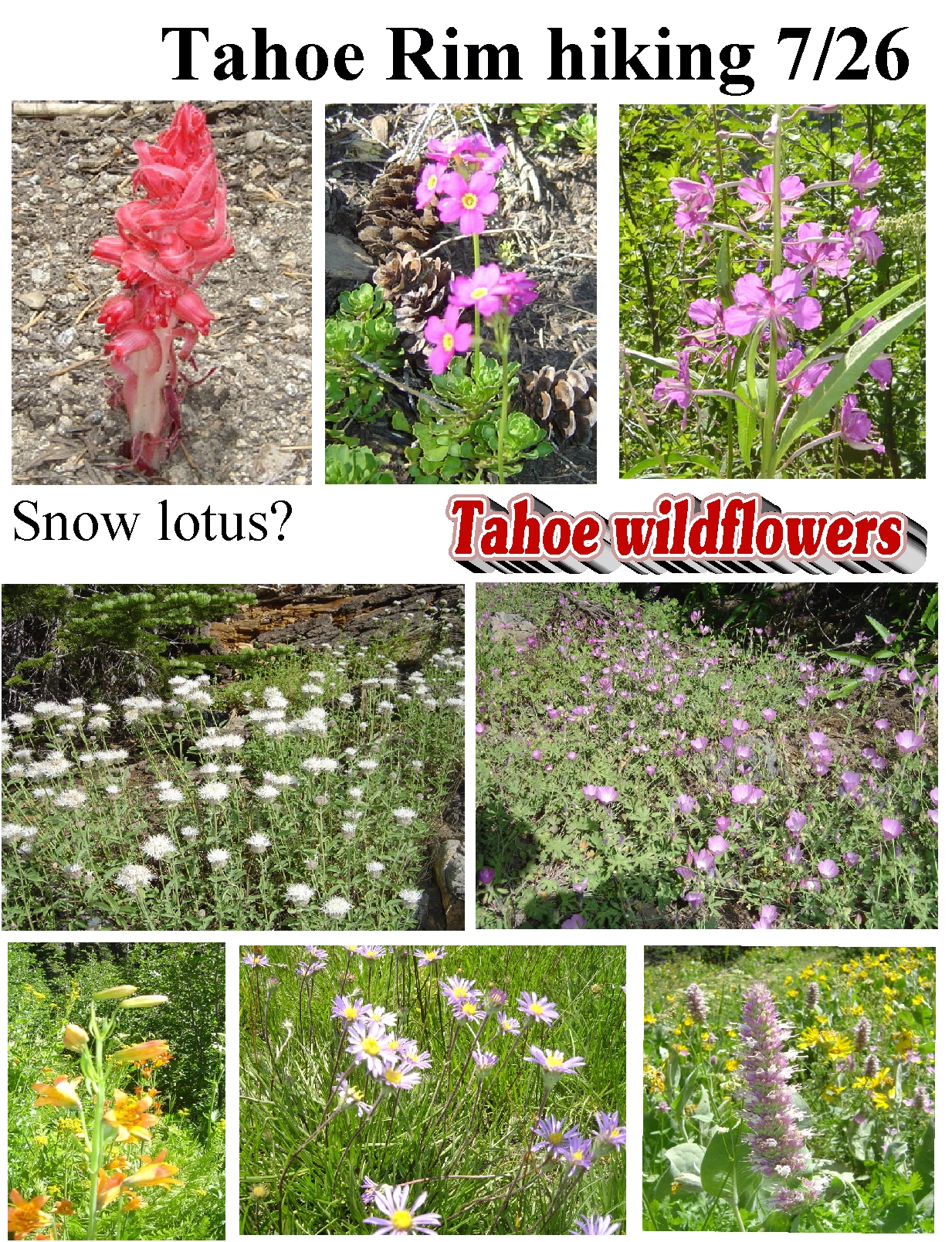
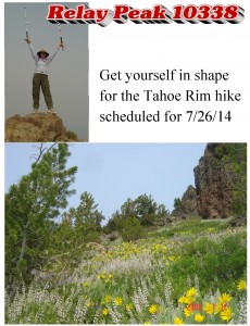
2014-09-20 Hiking, Alviso Marina County Park

2014-09-20 Hiking
Alviso Marina County Park to SFO Wildlife Refuge
Start at 3:00pm
Meeting Place: Parking Lot of Alviso Marina County Park

IMG_20140813_121831_616

This time, we will visit the south portion of San Francisco Bay Wildlife Refuge starting from Alviso Marina County Park.

It is a leisure walk without any climbing. Our route is famous at its beauty in sunset. So, we will start our trip late at 3:00pm this time. We should finish our trip between 6:00 to 6:30pm.

We will start our route at Alviso Marina County Park and walk to see the ghost town of Drawbridge. You can obtain detail information of this route from the link below.
http://www.tripadvisor.com/Guide-g60713-i4874-San_Francisco_California.html

After watching the ghost town of Drawbridge, we will walk around the salt pond A15. Or, you can return to Alviso Marina County Park from here as our short route. Round trip of this short route is about 4 miles. Salt pond A15 is famous for its pretty at sunset. This will give us additional 3 miles of this trip.

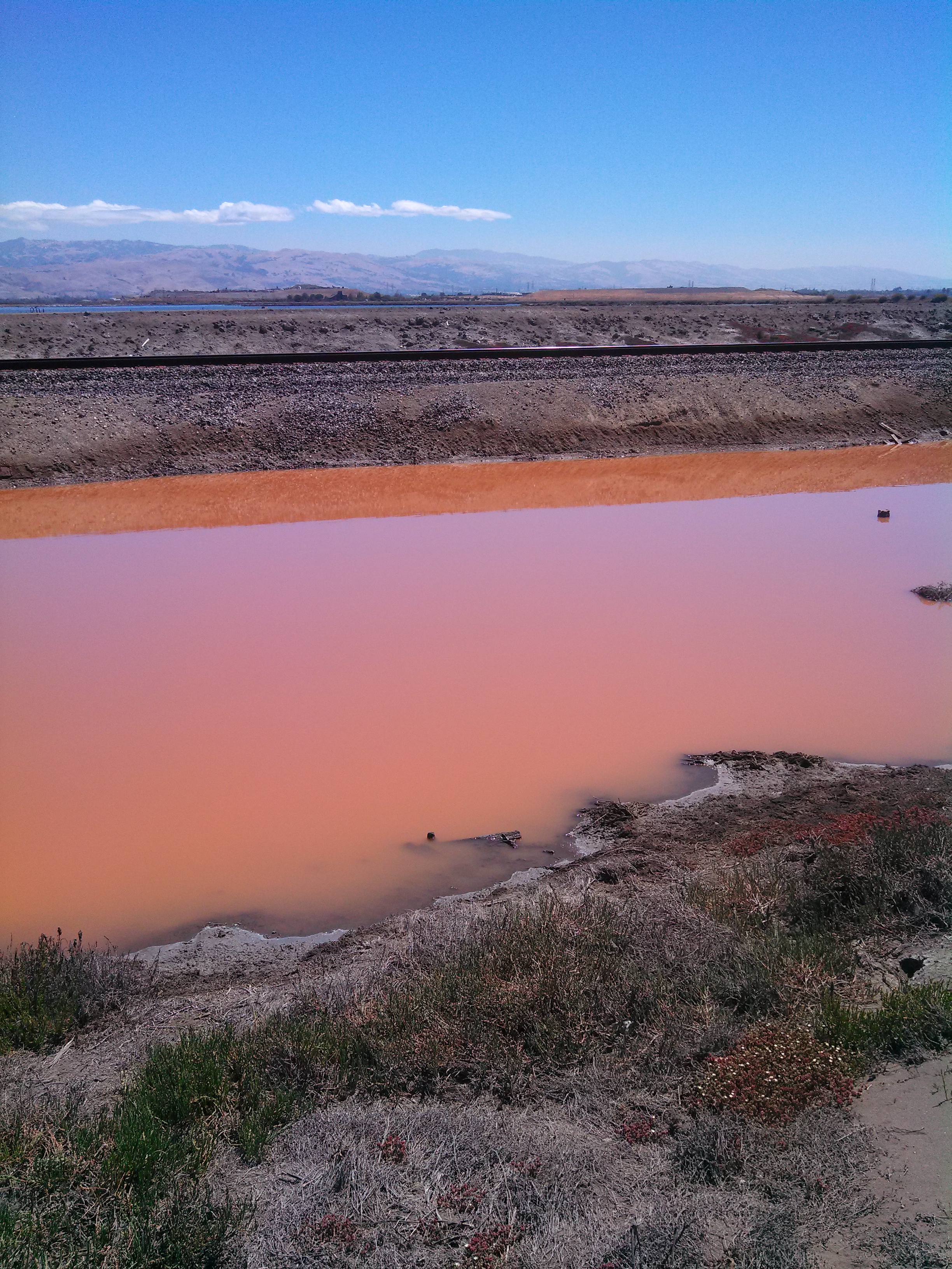
Do not forget your camera. The color of the salt pond of Alviso Weep will reflect different colors from time to time. Let’s see what are the colors that we can see this time.

(** Please note that all participants must take full responsibility to themselves.  NCCUAA-NC is not responsible to any indemnity on any occurring in this event.  If you do not agree on this term, please do not participate in this event. **)

What to bring:

  •  A signed wavier form ( download from this link, http://www.ncuaanc.org/?attachment_id=2103 )
  •  Plenty of water; hiking pole is not required.
  •  Sun glasses, hat. (100% no shed)
  •  Use sunscreen and make sure you’re wearing weather-appropriate clothing. Exposed areas of the bay can be very windy.
  •  No dog. Pet is not allowed in this refuge.

Direction:
1. Address of Alviso Marina County Park is 1195 Hope St, Alviso, CA 95002
2. Take Hwy237, exit Great America Parkway
3. Turn to the seashore direction for Gold Street Connector
4. Turn left to Gold Street
5. Gold Street to the end will be Elizabeth St.
6. End of Elizabeth St. will be Hope St.
7. Turn right to Hope St. and enter to the Park.
8. Parking is free.

2014-4-19 Hiking Club – Sunol Regional Wilderness

carol_sunol Location: Sunol Regional Wilderness Park,神麓自然保護公園, Address:  1895 Geary Road, Sunol, CA.                                   Date:   4/19/214 (Sat) 1:30pm to 5:30pm.

Note:    We will meet at the picnic area in front of the Visitor Center, please notice there is $5 entrance fee to the park.

Weblink:   http://www.ebparks.org/parks/sunol

Description: 

We will meet at the picnic area in front of the Visitor Center.  We will start at 1:30pm from the Indian Joe Nature Trial to the Canyon View Trial.  About 1 mile, we will reach the Little Yosemite.  For people taking the short route, they can take the Camp Ohlone Road here back to the Parking Lot.   For the regular route, we will continue our route from Little Yosemite by taking the Cerro Este Road uphill to the landmark of SO33.  Turning to the Cave Rocks Road and the Indian Joe Creek Trial, we will enjoy the beautiful scenery and gradually go down the hill.  The regular route is about 5.6 miles, and the difficulty is rated moderate.  The short route is about 2.1 miles.

  • There is a $5 entrance fee to this Park.  Ask and get a map at the entrance.
  • Parking lots are scattered at several Parking Area.  After you park your car, look for the Visitor Center and we will meet there.  This Park is dog friendly.
  • For people need an address for GPS:  1895 Geary Road, Sunol, CA


(Please note that all participants should take full responsibility to themselves in this event. Please aware that NCUAANC is not responsible to any indemnity on any occurring in this hiking event. If you do not agree on this term, please do not participate in this event.)


What to bring:

– Plenty of water, snacks.

– Sun glasses, sun screen and hat.

– Hiking boots and hiking pole are suggested.

–  A jacket.

Directions to reach The Park

  • From the Fremont area:
    Drive north on I-680 and exit at Calaveras Road. Turn right on Calaveras and proceed to Geary Road, which leads directly into the park.
  • From the Oakland/Berkeley area:
    Drive east on I-580 to the junction with I-680 in Pleasanton. At the junction, go south on I-680 and exit at Calaveras Road/Highway 84 just south of the town of Pleasanton. Turn left onto Calaveras Road and proceed to Geary Road, which leads directly into the park.
  • From the Walnut Creek/Danville area:
    Go south on I-680 and exit at Calaveras Road/Highway 84 just south of the town of Pleasanton. Turn left onto Calaveras Road and proceed to Geary Road, which leads directly into the park.


2013-10-26 健行活動公告

Oct-hiking
Monument Peak – Ed Levin County Park
3100 Calaveras Rd
Milpitas, CA 95035
Hiking Date : 10/26/2013 (Saturday)
Time: 1:30pm to 5:30pm
秋高氣爽, 最宜登山. 今次健行,目標是位於Milpitas 市的 Ed Levin County Park 內的Monument Peak.
  Monument Peak 標高 2,595呎. 我們從公園內的Sandy Wool Lake 出發,全程約7.8哩, 登高約2,000呎. 因山徑婉延而上,所以坡度並不太斗峭, 難度適中.
We will meet at 1:15pm and start our hike at 1:30pm.
Meeting Place: the parking lot in Sandy Wool Lake area inside the Ed Levin County Park, Milpitas, CA 
 
This hike is from Sandy Wool Lake area in Ed Levin Park to Monument Peak summit via the Monument Peak Trail, and is great for hiking.  The difficulty rating of this trail is moderate.
To ascend, we will take the Tularcitos Trail, Agua Caliente Trail and Monument Peak Trail.  To descend, retrace our steps of Monument Peak Trail , and take theAgua Caliente Trail to the Calera Creek Trail, then to Sandy Wool Lake.  There are 7.7 miles for this loop.
If you do not want to hike to the peak, you can continue Agua Caliente Trail instead of turning right to Monument Peak Trail and directly go to Calera Creek Trail, then back to Sandy Wool Lake.  This short loop is about 3.4 miles. 
Please refer to the attachment for more details.
 (Please note that all participants should take full responsibility to themselves in this event. Please aware that NCUAANC is not responsible to any indemnity on any occurring in this hiking event. If you do not agree on this term, please do not participate in this event.)
 
What to bring:
–          Plenty of water, snacks.
–          Sun glasses, sun screen and hat.
–          Hiking boot and hiking poles are strongly recommended.
–          A jacket. (It may be windy at the hill top.)
Directions:
–          Traveling on either Interstate 680 or 880, take the Calaveras Blvd exit inMilpitas.(If you travel by 237, end of 237 will be Calaveras Blvd.)
–          Drive east towards the foothills and becomes Calaveras Road.  Drive alongCalaveras Road.
–          There are two main use areas in the park. The Sandy Wool Lake area is located north of Calaveras Road and the Spring Valley Pond area is located south of Calaveras Road.   U(If you use GPS or Google Map for Ed Levin County Park, it may guide you to the Spring Valley Pond area.)
–          To reach the Sandy Wool Lake area, take a left turn off Calaveras Road onto Downing Road. Travel north along Downing Road to reach Sandy Wool Lake.

2013-8-17健行活動公告

Aughiking  Hiking Date : 08/17/2013  Time: 1:30pm to 4:30pm, Meeting Place: the picnic table area in the Wunderlich Park.  Address: 4040  Woodside Road, Woodside, 94062.

The Wunderlich Park is a hillside area of redwood forest, open meadows, and beautiful oaks and madrones. The park is largely open space, with a system of beautiful trails. Both riding and hiking are available. Much of the park is well


shaded, so it’s a good hiking choice in summer days. 

There are quite a few loop possibilities. We hiked the ambitious one to the Skyline Boulevard edge of the preserve about 9.9 miles round trip. We also hiked a shorter one with 4.4 miles. This time, we will try a new route for easier handling.

Starting from the Parking, we will take the Alambique Trail to the junction of Bear Gulch Trail. After 0.3 miles on the Bear Gulch, we turn right to the Meadow Trail, then left to Madrone Trail, and hit the last portion of Bear Gulch Trail back to the parking. This route is about 4.8 miles. We should finish it within 3 hours.


 (Please note that all participants should take full responsibility to themselves in this event. Please aware that NCUAANC is not responsible to any indemnity on any occurring in this hiking event. If you do not agree on this term, please do not participate in this event.)

What to bring:

  • Plenty of drinking water, snacks.
  • Sun glasses, sun screen and hat.

Directions:


Take Hwy 101 or I280 turn to Woodside Rd. Staying on the Woodside Road, head west to Woodside City. After driving through the Woodside city, head north on Hwy 84, the Wunderlich County Park will be on your right hand side.

Please aware the 25 mile speed limit in Woodside City. Police always hunts for overspeed vehicles there.

  • If you can’t find parking space in the Park, you can park at the road side of Woodside Road outside the Park. Do not park at the reserved parking for the equestrian loading. You may be cited or towed by the Park Ranger.


2013-9-8 中秋烤肉與健行活動

BBQ_picture Date:  2013-09-08  Sunday, 11 AM,      Event:  BBQ in the Park, Place:  Kennedy Grove Regional Park (6531 San Pablo Dam Road,  El Sobrante, CA)

親愛的師長及校友:

 大家期盼已久的中秋烤肉活動將訂於星期日, 9月8日上午11在東灣  Kennedy Grove Regional Park (6531 San Pablo Dam Road,  El Sobrante, CA) 舉行.   

我們將準備豐盛的烤肉及可口點, 並安排豐富的娛樂節目, 包括民歌欣賞, 陳萍帶領大家做拉丁有氧健身運動, 舒活筋骨, 以及有趣的遊戲.  李仁龍帶領的 Hiking Club 9活動也合併在當天下午舉行.  大家可漫風景優美寬闊草原, 擁抱大自然.  中秋烤肉活動是一項十分受歡迎的活動, 歡迎校友們闔家光臨.  請現在就報名, 期待與大家共度一個愉快的中秋佳節. 

我們也將舉辦 yard sale.  校友們可以清理家中不用的東西, 二手或全新的用品.  需要的人可以低價買到, 可資源回收.  全部收入將捐給校友會.   歡迎校友們帶著您的家人, 朋友踴躍參加.  期待大家參與, 聯絡感情, 為這次活動留下美麗的回憶.

 費用:  人 $10,  小孩 (6-12)  $5, 長者 (70+) $5

支票抬頭請支付“NCUAA-NC”, 請寄到 Amy Chang (1085 Caggiano Ct. San Jose, CA 95120)

報名截止:  9/4/2013

聯絡人:

江宜芳 (Emily Chiang): emily.chiang@cbnorcal.com   650-796-2285 

簡美雪 (Amy Chang): snoweeamy@yahoo.com   408-464-6633

Carpool 請聯絡: 衡孝英 (Caroline Heng): caroline_heng@yahoo.com  408-366-0678

 Yard Sale 及志工請向廖富美 (Michelle Wu) 登記 wu.michelle@principal.com, 408-821-8279. 請校友儘速報名參加.  感謝您的支持與合作! 

 活動組組長: 耿德馨及簡美雪, 廖富美, 張莉綺, 衡孝英, 江宜芳, 吳敏君, 杜希婷, 程長龍 敬邀

  DIRECTION:

From SF Peninsula

1. Cross Bay Bridge , stay on the left lanes and go Hwy. 80 ( Sacramento ).

2. Pass Berkeley , Albany , El Cerrito and exit San Pablo Dam Road.

3. Make a right onto San Pablo Dam Road. Go all the way.

4. You’ll pass about 12 intersections / traffic lights until all the residential areas are behind you. Then you’ll begin to climb an uphill slope.

5. Very soon, Kennedy Grove appears at your left. Make a left turn you’ll face a winding downhill road to the parking kiosk.

$5.00 per car.

If you take San Mateo Bridge , do exactly the same as above – you’ll have to turn to Hwy. 880 ( Oakland ) first and then merge to Hwy. 80 when you pass Oakland.  Make sure that you stay on the RIGHT lanes so that you’ll make it to Hwy. 80. Otherwise, you’ll go to Bay Bridge and San Francisco .


From South Bay

1. Take Hwy. 680 North ( Sacramento ) – highly recommended!

2. Go all the way on 680 and stay on the right lanes after you pass Alamo. You then will merge to Hwy. 24 West ( Oakland ).

3. Stay on 24 and exit Orinda.

4. Make a right onto Camino Pablo. You’ll pass the residential area of Orinda. Stay on the same road and the road name changes to San Pablo Dam Road.

5. You’ll enter a scenic drive. San Pablo reservoir is at your right. Hill slopes at your left. Once you pass the entrance of San Pablo Reservoir, begin to REDUCE speed, go about another quarter of a mile, the entrance of Kennedy Grove lurks at your right. You have to make a SHARP right turn onto a winding downhill road to the parking kiosk.

If you decide to take Hwy. 880 ( Oakland ) please follow the same directions as that of the SF Peninsula goers.

 From Oakland and Berkeley

1. Take Hwy. 24 East ( Walnut Creek ). Cross Caldecott Tunnel.

2. Exit Orinda. Make a left onto Camino Pablo.

3. Follow the same directions as that of South Bay goers who take Hwy. 680 North.

From Marin

1. Take Richmond / San Rafael Bridge.

2. Stay on Hwy. 580 West and exit Harbor Way. Left onto Harbor Way and then immediately right onto Cutting. Go all the way until you reach the entrance of Hwy. 80 East. Go onto Hwy. 80 East.

3. Follow the same directions as that of SF – Peninsula goers.


2013-7-20 NCUAA-NC Hiking Event

Windy Hill Open Space Preserve
2013-7-20-Hiking_event

  NCUAA- 2013 July Hiking Event 

Place: Windy Hill Open Space Preserve

Time: July 20, 2013 (Saturday), 13:30- 17:30

Mee at :  The upper portion of this Preserve at Skyline Blvd., it is called the Spring Ridge Parking Area, 18362-18492 California 35, Portola Valley, CA .


Driving instructions:

** Please note that we will park at, and start from the upper portion of this Preserve at Skyline Blvd., the Spring Ridge Parking area. Do not get direction from google map by the address of this Preserve. It will direct you to the lower portion parking.

From hwy 280, take hwy 92 west, then turn south onto hwy 35 (Skyline Blvd), drive for 14.3 miles, the parking lots at your left. We will park at the one with portable toilet. (the 2nd parking lot on the map)

If you need address of this parking lot, the Spring Ridge Parking Area, 18362-18492 California 35, Portola Valley, CA .

*********************************************

You can download a map from the link below.

http://www.openspace.org/preserves/maps/pr_windy_hill.pdf

******************************************

Description:

It is one of the our three choices for the hot summer. The trails are mostly shaded under pines, bay trees and live oaks.

We start from the upper portion of this Preserve. We will take our modified route as last time for going downhill with the shorter 2.6 miles Hammer Gulch Trail, then upward back to parking lot with the 2.3 miles Razorback Ridge and 1.5 miles Lost Trail. From our past experience, people can handle this route very easy by this modification. The whole route is about 7.8 miles.

(Please note that all participants should take full responsibility to themselves in this event. Please aware that NCUAANC is not responsible to any indemnity on any occurring in this hiking event. If you do not agree on this term, please do not participate in this event.)

**************************************************************

What to Bring:

Drinking water, snacks, sun glasses, sun screen, hiking boots, hiking poles.

*** It may be quite windy at the time we finish the hiking, so a light jacket is recommended.


You can call Paul Lee at: (510)-676-1343


for questions of this event.


********************************************************


六月廿二日健行活動公告

Tolman Peak Trial
  • Date: 06/22/2013 (Saturday)
  • Time: 1:15pm to 4:30Pm
  • Meeting Place: Public Parking Lot at May Road, Union City

六月健行在6/22 舉行。今次健行將是登山活動。


Overview

Tolman Peak (997 ft. elevation) is located at the southeast side of Garin / Dry Creek Pioneer Park, which is part of East Bay Regional Park System.

We will meet at the public parking lot at May Road, Union City at 1:15pm.  The parking is free.  We start here at1:30pm to the peak and back.  Our route is 4.75 miles round-trip, and we should be finished within 3 hours.  The Difficulty rating of this trail is “Easy” for usual hikers.

It starts with easy uphill hike, several creek crossings until a moderate uphill climb to Tolman Peak.  After the peak, we will take the South Folk Trail, a well-shaded trail in the oak woods, to complete the loop around the hill and then takes the same way back to the trailhead. This is a great hike for people looking for solitude and great scenic views on the east bay. The best season to hike is early summer.

You can get more details of this trail from the link below.

http://www.everytrail.com/guide/tolman-peak-hike

(Please note that the introduction from the link above starts from Tamarack Ave, and we start from May Road.  Don’t  use the information from the link and wrongly go to Tamarack entrance.)

You also can get a park map from this link.

http://www.ebparks.org/Assets/_Nav_Categories/Parks/Maps/Garin+map.pdf

(Our route is at the lower right corner of the map.)


Directions

Directions to the May Road Parking:

The May Road is very short.  You can even see the parking lot before you turn in May Road from Mission Blvd.  You won’t miss it.

From Peninsula or South Bay,

  • Using Hwy 237, Hwy 95 or Hwy 84 to reach I880.
  • Following I880 instructions below.

People Using I880:

  • Take Decoto Exit, eastbound to Mission Blvd, Hwy 238.  (With Hwy 84, after crossing the bay, it will be Decoto automatically.)
  • Turn left at Mission Blvd.
  • The first traffic light after the turn will be May Road, turn right heading to the Parking Lot.

People Using I680:

  • Southbound, take Mission Blvd Hwy 238 exit.
  • Northbound, take the 2nd Mission Blvd exit of Hwy 238.
  • Using Mission Blvd head north to Union City.
  • After the Decoto, it will be May Road.
  • Turn right at May Road to reach the parking lot.

The sign of May Road is small, and easy to be missed.   There is a Shell gas station just opposite to the May Road.  Look for this station.

Please be reminded that do not park in parking spaces of the neighborhood apartments.  Towing cars always hunt at this area.  If the parking is full, you can park at the road side at Mission Blvd.


What to bring

  • Plenty of water.
  • Hat, sun screen for a sunny day. (2/3 of the route is unshaded.)
  • A spare jacket for the wind at the peak.
  • Hiking boot and hiking pole are recommended.


Attachment

Please see the PDF file for more information. Hiking-2013-06-Tolman.pdf

Please note that all participants should fully aware that NCUAANC is not responsible to any indemnity on any occurring in this hiking event.  If you do not agree on this term, please do not participate in this event.

四月二十七日健行活動預告


 Edgewood County Park
Redwood City, Edgewood County Park

  Register:  Please email to Paul Lee at :  paullee_usa@yahoo.com  

 He needs to have the total headcounts to register a group tour – “Springtime Wildflower Walk”.

有意參加者請向李仁龍校友以email 報名。如果人數很多,必須事先報備。

  Description:  

春到人間百花爭艷,又是賞花好時候.  4/27 我們會到 Redwood City 的 Edgewood County Park 参加它們的
Springtime Wildflower Walk.  (在此感謝杜振華學長,推薦此好去處!)
– 今次活動是在早上10:00am開始, 1:00pm 前結束. 我們於 9:45am 公園正門集合.
– 有意參加者,請於4/15 前告知. 如人數眾多, 我需事前通知 Friends of Edgewood.
– 公園及活動詳情可參閱下列網址:
http://www.friendsofedgewood.org/edgewood-county-park
http://www.friendsofedgewood.org/springtime-wildflower-walks
http://www.co.sanmateo.ca.us/portal/site/parks/menuitem.f13bead76123ee4482439054d17332a0/?vgnextoid=a76bc8909231e110VgnVCM1000001d37230aRCRD&cpsextcurrchannel=1

Our school brother, Michael Tu introduces Edgewood County Park and suggests us
to play a visit in this flower blossoming season. We will take his valuable
recommendation, and join the Springtime Wildflower Walk activity. Activity
starts at 10:00am and ends before 1:00pm. You can refer to the 3 links above
for much detail information for the park and the walk.

If we have a big group, we need to inform the Friends of Edgewood advance for
the tour guide arrangement. (Hope that Michael can be our guide.) Please send
reply to me for your interest to attend on or before 4/15.

Also, please be reminded that this is a morning activity. We will gather at the
Park main entrance at 9:45am on 4/27(Sat).

Rdgs,
Paul Lee
p.s. Participants should take full responsibilities on themselves in this
activity. NCUAA-NC should not be hold on any indemnity on any occurrence.


三月十六日健行活動預告

Date:   March 16 (Saturday) 2013, at 1:15pm

Place:  San Tomas Aquino Creek Trail

Addr:  5155 Stars and Stripes Dr, Santa Clara, CA


Please park your car at Santa Clara Golf and Tennis Club, which is free of charge. Then, walk to the tennis court area. We will meet there at 1:15pm, begin walk at 1:30pm.

Please call Paul Lee at (510)-676-1343 on 3/16, if you need help.

Descriptions: 

今次健行, 是為校友設計的新路線. 含溪邊堤防道, 防洪調節區,海邊濕地保留地. 全程均為平地, 無斜坡, 適合闔家老幼.  此 路線含San Tomas Aquino Creek Trail, South Bay Trail, Baylands Park Trail 三條步道徑中的候鳥南來此處的主要棲息地. 大雁,水鴨,鴛鴦,鷺鷥散落各處. 你會發現雁兒不在林梢,而在這些溪湖中.    Baylands Park 適合親子活動. 你可携同小朋友走短路線, 在此遊樂, 等待走正常路線大夥在此會合, 再一同回程.

What to bring:

(Except the first few hundred feet with shade, the whole trip is open without shade. )

– Conditions upon the weather, you should bring hat/cap, sunglass, sunscreen lotion etc for a sunny day.

– You should always have a jacket ready for a windy day at the seashore.

– Plenty of water. Snack at break for recharging.

– A pair of comfortable walking shoes.

– Hiking pole is not necessary.

========= ======================================

MORE DETAILS:

 This route is new to NCCUAA-NC, which includes portions of the San Tomas Aquino Creek Trail, South Bay Trail and Baylands Park Trail. I name it with the leading charter of each trails. It is a good warm up route for a new activity year. It is a pure health/leisure walking route without any climbing involved. It should serve most of the ages.

There is an alternative shorter distance of this route. For the regular route, the approximate distance is about 6 miles. The short route is about 4 miles.

From there, we will walk to the trail access point of San Tomas Aquino Creek Trail right behind the Santa Clara Convention Center.

A. We then head north 1 mile to the beginning of the San Tomas Aquino Creek Trail.(1 mile)

B. We will walk in the swam preserve area to watch the transients, then back to the Baylands Park Trail for the access point to the South Bay Trail. (0.7 mile)

C. For people who take the shorter option, they can directly walk to the Baylands Park from here to take rest there, and enjoy the facilities of this Park.(0.4 mile)

D. For people who take the South Bay Trail, there are 2 miles including some street walking to Baylands Park.

E. After taking a break at Baylands Park, we will walk back to the parking through Baylands Park Trail + San Tomas Aqunio Creek Trail with 1.8 miles.

We should return to the Parking around 4:30pm.

Drive Directions:   To Santa Clara Golf and Tennis Club.

From 237, take Great America Parkway Exit towards Great America Parkway;

Turn left at Tasman Dr. ;

Turn left to Centennial Blvd.

From 101, take Great America Parkway Exit towards Great America Parkway;

Turn right at Tasman Dr.;

Turn left to Centennial Blvd.

(After turn in Centennial Blvd, GPS may tell you to turn left for the arrival of destination. So, the parking spaces at there are always occupied. Instead of turning left, turn right to the big parking lot right next to the Fire Station, there are always parking spaces available. Also, there are a lot of street parking spaces right opposite to this parking lot for the Great America Amtrak Station. They are also available with free of charges. ) Park your car, then walk to the Tennis Court area.

Need help on direction, call Paul Lee (510)-676-1343

 What to bring:

(Except the first few hundred feet with shade, the whole trip is open without shade. )

– Conditions upon the weather, you should bring hat/cap, sunglass, sunscreen lotion etc for a sunny day.

– You should always have a jacket ready for a windy day at the seashore.

– Plenty of water. Snack at break for recharging.

– A pair of comfortable walking shoes.

– Hiking pole is not necessary.


For details of San Tomas Trail:

http://www.rhorii.com/STACT/SanTomasTrl.html


p.s. Participants should take full responsibilities on themselves in this activity. NCUAA-NC should not be hold on any indemnity on any occurrence.


Please see the PDF file for more information – SSB Route.PDF