Hiking photos can be found in the section of “校友會相簿“.
Hiking Club
Hiking photos can be found in the section of “校友會相簿“.
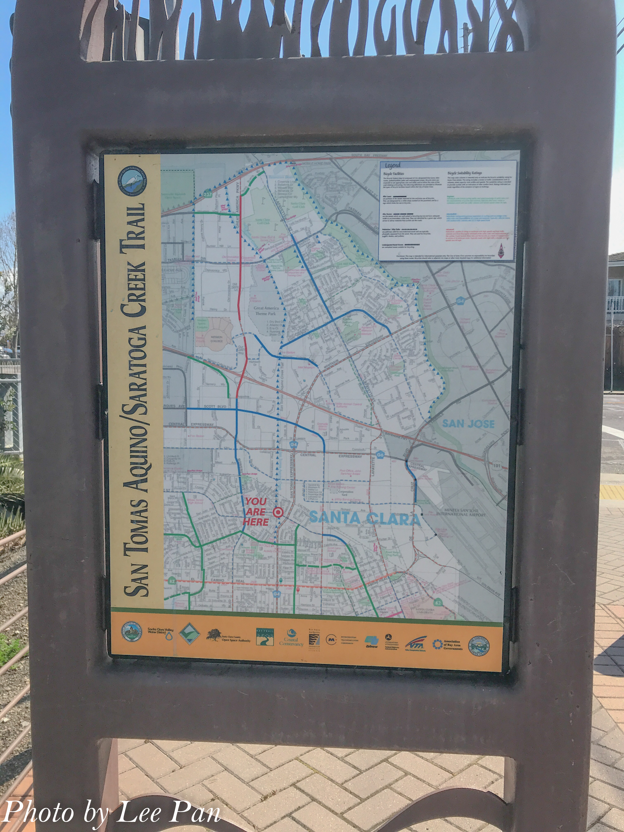
San Tomas Aquina Trail, Santa Clara
Meeting time: 1:10pm
Meeting place: Santa Clara Golf & Tennis Club, 5155 Stars and Stripes Dr., Santa Clara, CA
This is our first hiking event in 2019. Let’s start with an easy one.
We will meet in front of the multilevel public parking building next to the tennis courts. We start at 1:30pm from the Santa Clara Golf & Tennis Club toward south to its trail head at Monroe St., then back to Parking. The whole trip, forth and back, has about 6 miles of paved road.
This golf club is just opposite to the Levis Stadium, both VTA and Amtrak stations are nearby.
What to bring:
1. A signed Waiver form. (You can download one here : 國立政治大學北加州校友會 » Blog Archive » NCCUAA-NC WAIVER FORM
2. If it is a sunny day, please bring your sunglasses, hat/Cap and sun screen lotion. If it is a windy day, please bring a light jacket with you.
3. Plenty of water, light snacks.
4. Leisure dresses and sport shoes.
Date : 11/3/18 (Sat)
Meeting Place: Parking lot of the Park
Meeting Time: 1:15 pm

We will start at 1:30pm. We will walk from the Parking Lot to the opposite band of the Ghost Town, Drawbridge, then return to the Parking Lot. It is a leisure walk along the salt ponds of this Park. The whole trip is about 4.2 miles. (No pet is allowed in this Park.)
How to Get There
Alviso Marina County Park is located at:
1195 Hope St San Jose, CA 95002
Directions:
From Highway 880:
Take Highway 237 (Alviso-Milpitas Road) west to North First Street exit. Turn right on North First Street (which becomes North Taylor); turn right on Gold Street, left on Elizabeth Street and right on Hope Street.
From Highway 101:
Take Highway 237 (Mt. View-Alviso Road) east to Great America Parkway exit. Turn left onto Great America Parkway, turn right on Gold Street connector, left on Gold Street, left on Elizabeth Street and right on Hope Street.
What to bring:
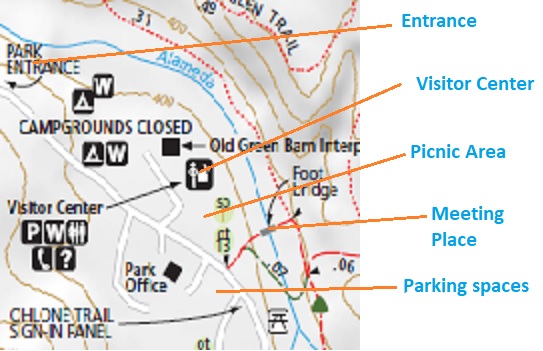
Date : 9/22/18 (Sat)
Meeting time : 1:10 pm
Meeting place : The picnic table area in the Park
Park Address : 4040 Woodside Road, Woodside, CA 94062
The Wunderlich Park is a hillside area of redwood forest, open meadows, and beautiful oaks and madrones. The park is largely open space, with a system of beautiful trails. Both riding and hiking are available. Much of the park is well‐shaded.
We will start at 1:30pm, and take the Alambique Trail uphill, then take the Bear Gulch Trail downhill back to the parking lot. This route is about 4.3 miles with very gentle slope. We should finish it around 4:30pm.
Directions:
** Please aware the 25 mile speed limit in Woodside City. Police always hunts for over‐speed vehicles there.
** If you can’t find parking space in the Park, you can park at the road side of Woodside Road outside the Park.
What to bring:
We will have our annual BBQ event at Baylands Park, Sunnyvale on 5/6/18. Our April/May hiking event will be held at the same date.
We will gather at Santa Clara Golf & Tennis Club at 10:15 am. Start our trip at 10:30 am. Walk with leisure for 1.7 miles to Baylands Park to have our BBQ lunch. Of course, you need to walk another 1.7 miles back to your parking after our BBQ event.
The whole trip is paved road, and is baby stroller friendly. Good for whole family to join. But pet is not allowed in Baylands Park.
Gathering :
Santa Clara Golf & Tennis Club,
5155 Stars and Stripes Dr, Santa Clara, CA 95054. (Opposite to Levis Stadium)
Time : 10:15 am.
What to bring:
Below is the BBQ event registration information.
Go to the link below for registration. (For food preparation, please register advance.)
(Right click the link below and click “Open Link”)
費用:每人 $10 (校友及親友統一價格);鼓勵親子一起參加,12歲以下孩童免費參加
繳費方式: pay in advance :
Paypal : JanePan95014@gmail.com
Mailing a check : 抬頭 NCUAA-NC
Check mailed to Address :
480 Mission Bay Blvd. North, Unit 810, San Francisco, CA 94158
Or 活動當日繳費: 現金或支票 (抬頭:NCUAA-NC)
National Chengchi University Alumni Association-Northern California
3/17/2018 (Sat) 1:15pm to 5:30pm
Hiking at Sunol Regional Wilderness,
http://www.ebparks.org/parks/sunol
We will meet at the cross bridge at the back of the picnic area, next to the Visitor Center at 1:15pm. We will start at 1:30pm from the Indian Joe Nature Trial uphill to the Cave Rock Road. From Cave Rock Road, we hike to the Cerro Este Road, then downhill to the famous Canyon View Trail. After we reach the McCorkle Trail, we walk down the hill and walk back to parking lot. The whole route is about 5.6 miles with some gentle uphill climbing.
Please visit the enclosed link above to get more details about this park and route.
(Please note that all participants should take full responsibility to themselves in this event. Please aware that NCUAANC is not responsible to any indemnity on any occurring in this hiking event. If you do not agree on this term, please do not participate in this event.)
Please note that people had been wrongly directed by their GPS to somewhere else before. Please read the directions below to check the suggested route of your GPS.
What to bring:
– A signed waiver form from our official web site. http://www.ncuaanc.org/nccuaa-nc-waiver-form/ (Move your mouse pointer to the top of the document, the download icon will be shown.)
– Plenty of water, snacks.
– Sun glasses, sun screen and hat.
– Hiking boots and hiking pole are suggested.
– A jacket.
Directions to reach The Park
Hiking: July 8, 2017 (Sat)
Alameda Creek Trail
Gathering time : 1:15pm (7/8/2017)
Start time: 1:30pm
Meeting Place : Niles Staging Area parking lot at Old Canyon Road, Fremont.
We did not have any hiking activity in May and June. We will have one in early July. It is a leisure walk about 6 miles with no slope climbing. We start at 1:30pm and should finish it before 5:00pm.
We will start from the trail head at Niles Staging Area. We walk along the south band of the trail to reach the Sequoia Bridge, then enter to the Quarry Lake Park. We walk along the lake side and exist from the south entrance of the Park, then cross the Sequoia Bridge return to the Staging Area.
What to bring:
Directions :
We will meet at the Stream Trail head next to the last parking lot at 11:30am. We then have a leisure walk for 0.9 mile to the “Trail End” picnic area for a picnic before continue our hiking. If you don’t want to join our picnic, come to the picnic area to meet us before 1:00pm.
We will continue the Stream Trail at 1:00pm for 1.3 miles to reach the Girls’ Camp. We will begin to walk up to the hill for about 300ft. in 0.42 mile. We then take the West Ridge Trail to French Trail downhill to Tres Sendas Trail back to the Stream Trail. We take the Stream Trail back to Parking area. The whole route is about 5.8 miles including 0.9 mile to picnic area. We should be able to finish it around 4:30pm.
For people want to have a shorter route, they can return to Parking lot from Girls’ Camp on the Stream Trail. This roundtrip route is about 4.4 miles.
Direction:
Use your best route to I580, take I580 to CA-13. Take the Exit-1 for Carson St./Redwood Rd. Follow Redwood Rd. for 3.4 miles to the park.
What to bring:
More about the park:
Parking fee: $5.
(http://www.ebparks.org/parks/redwood )
Redwood Regional Park
7867 Redwood Rd.
Oakland, CA 94619
Map: http://www.ebparks.org/Assets/_Nav_Categories/Parks/Maps/Redwood+map.pdf