National Chengchi University Alumni Association-Northern California
3/17/2018 (Sat) 1:15pm to 5:30pm
Hiking at Sunol Regional Wilderness,
http://www.ebparks.org/parks/sunol
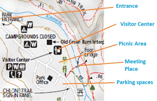
We will meet at the cross bridge at the back of the picnic area, next to the Visitor Center at 1:15pm. We will start at 1:30pm from the Indian Joe Nature Trial uphill to the Cave Rock Road. From Cave Rock Road, we hike to the Cerro Este Road, then downhill to the famous Canyon View Trail. After we reach the McCorkle Trail, we walk down the hill and walk back to parking lot. The whole route is about 5.6 miles with some gentle uphill climbing.
Please visit the enclosed link above to get more details about this park and route.
(Please note that all participants should take full responsibility to themselves in this event. Please aware that NCUAANC is not responsible to any indemnity on any occurring in this hiking event. If you do not agree on this term, please do not participate in this event.)
Please note that people had been wrongly directed by their GPS to somewhere else before. Please read the directions below to check the suggested route of your GPS.
- There is a $5 per car entrance fee to this Park. Ask and get a map at the entrance.
- This Park is dog friendly. ($2 per dog)
- Parking spaces at Visitor Center are limited. You can drive ahead and there is a big parking lot at your right hand side. It is across the road opposite to our meeting place. But it is very easy to miss. See map below.
What to bring:
– A signed waiver form from our official web site. http://www.ncuaanc.org/nccuaa-nc-waiver-form/ (Move your mouse pointer to the top of the document, the download icon will be shown.)
– Plenty of water, snacks.
– Sun glasses, sun screen and hat.
– Hiking boots and hiking pole are suggested.
– A jacket.
Directions to reach The Park
- From the Fremont area:
Drive north on I-680 and exit at Calaveras Road. Turn right on Calaveras and proceed to Geary Road, which leads directly into the park. - From the Oakland/Berkeley area:
Drive east on I-580 to the junction with I-680 in Pleasanton. At the junction, go south on I-680 and exit at Calaveras Road/Highway 84 just south of the town of Pleasanton. Turn left onto Calaveras Road and proceed to Geary Road, which leads directly into the park. - From the Walnut Creek/Danville area:
Go south on I-680 and exit at Calaveras Road/Highway 84 just south of the town of Pleasanton. Turn left onto Calaveras Road and proceed to Geary Road, which leads directly into the park.